


La Vilette

Dupuybadonniere
User
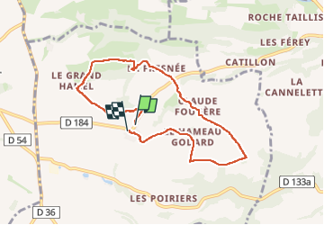

Length
7.2 km

Max alt
255 m

Uphill gradient
184 m
Km-Effort
9.7 km

Min alt
151 m

Downhill gradient
177 m
Boucle
Yes
Creation date :
2024-05-19 13:09:14.376
Updated on :
2024-05-19 15:34:03.043
1h53
Difficulty : Medium

FREE GPS app for hiking
 SityTrail
IGN / Geographical institutes
SityTrail Plus
The world is yours!
About
Trail Walking of 7.2 km to be discovered at Normandy, Calvados, La Villette. This trail is proposed by Dupuybadonniere.
Positioning
Country:
France
Region :
Normandy
Department/Province :
Calvados
Municipality :
La Villette
Location:
Unknown
Start:(Dec)
Start:(UTM)
680034 ; 5420708 (30U) N.
Comments